Last rites for the North Kerry Line
31st December 2024
Recording the last gasps of existence for this remote and long-forgotten route in the far south west of Ireland. 24th-26th June 1991
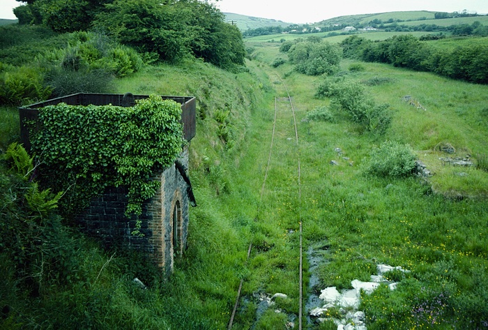
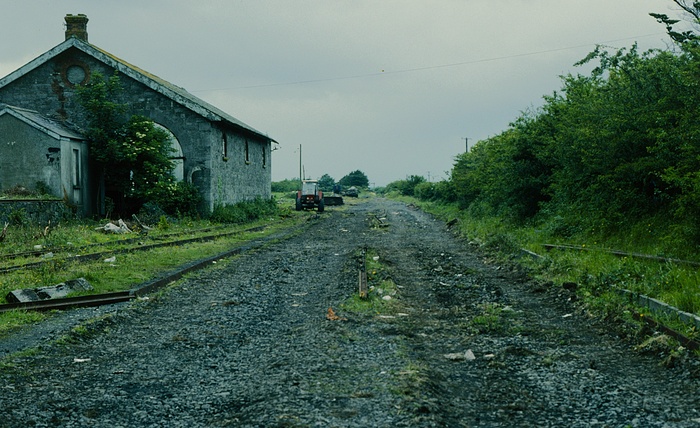
Looking east from the N21 overbridge at Barnagh station, near Ballymurragh. Track in situ and the water tower seemingly intact.
In 1991, whilst visiting South West Ireland, I came across a line that to be honest I knew little about. To be fair, there was not much left of it anyway but I was surprised, and a little delighted if I can say, to come across some incredible remnants of a route that finally closed to all traffic back in 1978. In the UK a line that would be closed was often ripped up fairly hastily, but in Ireland it seems that things went into stasis, maybe in the hope that business could be resumed one day. Sadly, not the case for the North Kerry line.
Oh dear, what a mess! Barnagh station looking east from the N21 overbridge. Track in place, but flooded (no more maintenance on the right-of-way). Dereliction all around.
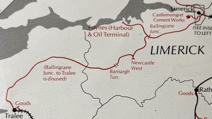
Linking Limerick with Tralee, County Kerry, the route passed through Newcastle West, Listowel(of Lartigue Monorail fame), Lixnaw and Abbeyforney, reaching Tralee just over 70 miles later. Built by two railway companies, the Rathkeale and Newcastle Junction Railway Company, and the Limerick and Kerry Railway Company, operation of the whole line was first undertaken by the Waterford and Limerick Railway when it opened in 1880. The WL&WR was acquired by the Great Southern and Western railway in 1901 and that company was merged into the Great Southern Railway at the time of the grouping of companies in Ireland in 1925. After the war, Coras Iompair Eireann (CIE) was created and this company saw out the final operations of the line. Closed to passengers in 1963, the line handled freight to Listowel until 1977 and to Tralee in 1978.
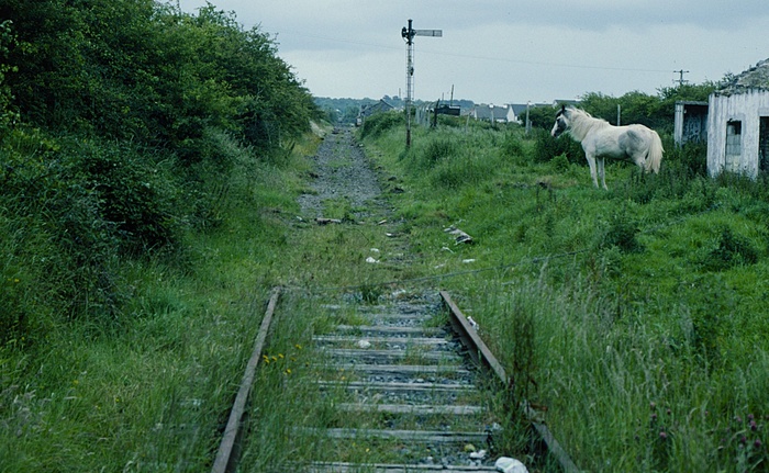
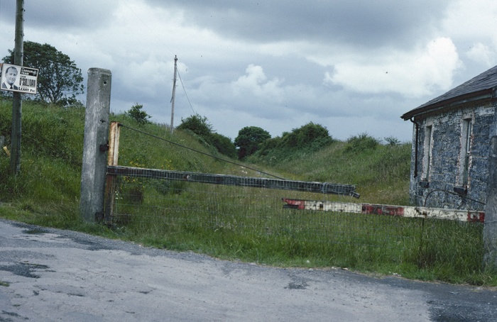
Close to Listowel, one horse power is all that's left. Track recovery in progress, this is a view from a level crossing near the town.
Track recovery in (slow) progress at Listowel. The goods shed remains.
Of course, it will always be argued why the line was built at all in the first place, given that it passed through some incredibly sparely populated country, but I am sure that agriculture was the main business in mind. I wonder if it would had had a future if the idea of the Western Rail Corridor reached further south than it currently does, plans being in place to open the whole route between Sligo and Limerick in the coming years.
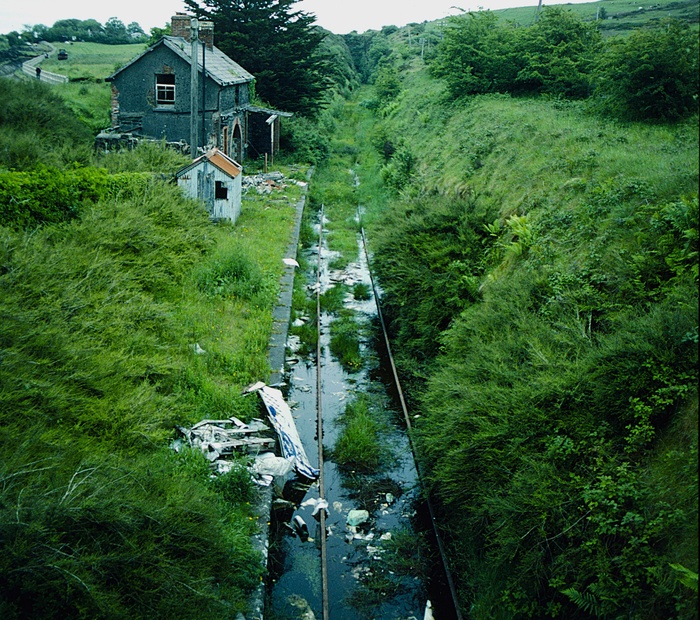
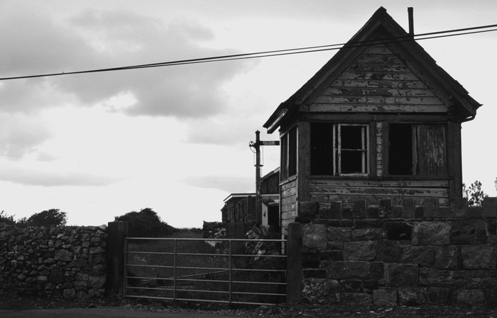
Elsewhere the lever frame would be removed first, but at Listowel, the opposite applies. What a sad sight, the wooden cabin all but gone, revealing the functional innards rusting away and no doubt for scrap.
This selection of photos shows what I found as I travelled south west from Limerick. It seemed that the further west I travelled the less track remained. Clearly lifting of the rails was a work in progress and they were in no hurry!7
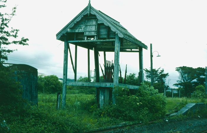
Above and below: all that remains at Lixnaw, between Listowel and Abeydorney.
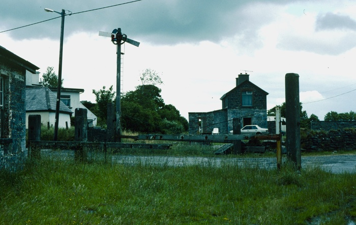
Abeydorney, a few miles north of Tralee. The ghosts of the past are represented by the derelict signal cabin and signal.
Looking east from the N21 overbridge at Barnagh station, near Ballymurragh. Track in situ and the water tower seemingly intact.
In 1991, whilst visiting South West Ireland, I came across a line that to be honest I knew little about. To be fair, there was not much left of it anyway but I was surprised, and a little delighted if I can say, to come across some incredible remnants of a route that finally closed to all traffic back in 1978. In the UK a line that would be closed was often ripped up fairly hastily, but in Ireland it seems that things went into stasis, maybe in the hope that business could be resumed one day. Sadly, not the case for the North Kerry line.
Oh dear, what a mess! Barnagh station looking east from the N21 overbridge. Track in place, but flooded (no more maintenance on the right-of-way). Dereliction all around.
Linking Limerick with Tralee, County Kerry, the route passed through Newcastle West, Listowel(of Lartigue Monorail fame), Lixnaw and Abbeyforney, reaching Tralee just over 70 miles later. Built by two railway companies, the Rathkeale and Newcastle Junction Railway Company, and the Limerick and Kerry Railway Company, operation of the whole line was first undertaken by the Waterford and Limerick Railway when it opened in 1880. The WL&WR was acquired by the Great Southern and Western railway in 1901 and that company was merged into the Great Southern Railway at the time of the grouping of companies in Ireland in 1925. After the war, Coras Iompair Eireann (CIE) was created and this company saw out the final operations of the line. Closed to passengers in 1963, the line handled freight to Listowel until 1977 and to Tralee in 1978.
Close to Listowel, one horse power is all that's left. Track recovery in progress, this is a view from a level crossing near the town.
Track recovery in (slow) progress at Listowel. The goods shed remains.
Of course, it will always be argued why the line was built at all in the first place, given that it passed through some incredibly sparely populated country, but I am sure that agriculture was the main business in mind. I wonder if it would had had a future if the idea of the Western Rail Corridor reached further south than it currently does, plans being in place to open the whole route between Sligo and Limerick in the coming years.
Elsewhere the lever frame would be removed first, but at Listowel, the opposite applies. What a sad sight, the wooden cabin all but gone, revealing the functional innards rusting away and no doubt for scrap.
This selection of photos shows what I found as I travelled south west from Limerick. It seemed that the further west I travelled the less track remained. Clearly lifting of the rails was a work in progress and they were in no hurry!7
Above and below: all that remains at Lixnaw, between Listowel and Abeydorney.
Abeydorney, a few miles north of Tralee. The ghosts of the past are represented by the derelict signal cabin and signal.